


Walkabout
"My grandmother started walking 5 miles a day when she was sixty. She's ninety-seven now, and we don't know where the hell she is." ~ Ellen DeGeneres
I had a very interesting and successful day today. It started out with a phone call early in the morning with great news. The phone call which I'd love to share with you has to do with the same reason I left my security job, and both will be reveled after April 15th.
Energetic from the phone call I got out of bed, had a healthy breakfast and took care of some minor stuff waiting for a call into work. Noon came and went without a call from work, so I figured it was safe bet that I wasn't going to be called in. Since I wasn't going to get any exercise from work I decided to go for a long walk, which turned into more of a walkabout, in the sense that I had know idea where I was going, or where I'd end up.
Here's a screenshot from my RunKeeper account:
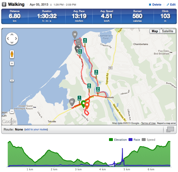 The walk started with a planned stop at the post office which is the furthest spot south-west on my route map. Once I picked up my mail I decided to head back and over to the Manuels River. In the past I've taken a trail that heads along the southern part of the river and only takes about 15 mins to complete. I felt like a change so I figured I'd try out the northern section of the trail (knowing nothing about it). The trail is pretty hilly, but it's well maintained. Thankfully most of the climbs and decents were aided with timbre steps.
Around the mid-point between the 3km and 4km marker the trail came right down to the rivers edge, which was way higher due to tons of rain and melted snow. I had to carefully step and jump from spot to spot to avoid getting wet. Hurdle #1 cleared
About 5 mins later the trail started to climb up higher and I came to a fork in the trail. I had the choice of following the main trail that looked like it headed east and possibly back out to a road, or turn left and continue north towards the ocean. My hope was (A) that the left trail would go all the way to the ocean, and (B) that there was a way to cross to the other side of the river, and (C) find a trail heading back in the opposite direction. That was a lot to hope for, so naturally I chose the latter.
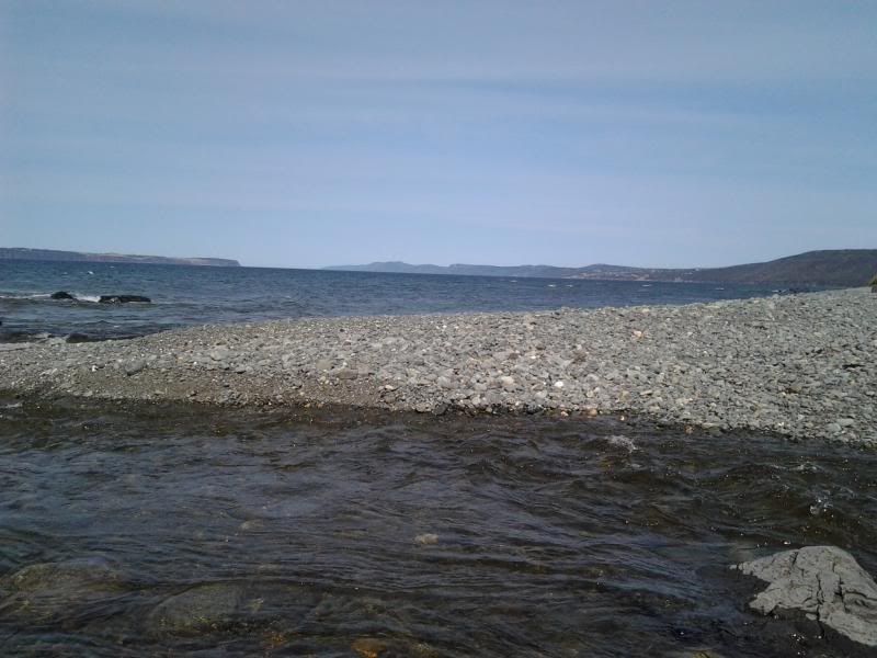
The side trail wasn't as well maintained or traveled, but it was still fun. At the 4km marker the trail ended at Worsley Park which I didn't even know existed until I arrived. The park led down to the ocean/beach*, and extended across to the other side of the river... well most of the way, which meant that both (A) and (B) worked out.
*Beach - For those of you not familiar with Newfoundland the majority of our beaches are rocky, although we do have a few sandy ones.
To get across to the other side I ended up removing my shoes/socks, rolled up my pants up to mid-thigh and waded through the fast running bitterly cold water. Luckily it only came up a bit above my knee's. Hurdle #2 cleared
Once I was successfully on the other side I sat down on a rock facing the sun and waited a bit for my legs/feet to dry off before putting my socks/shoes on. While I was waiting I took the following 360 degree (shaky) video which starts looking from over my left shoulder.
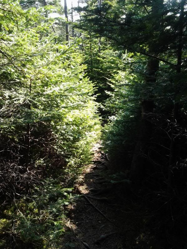
I had to climb up that big hill that was mostly loose rock/dirt and I managed to eventually find a very narrow overgrown trail that headed in the right direction. Hurdle #3 cleared
This is the trail before it got to narrow to take a picture
The trail started off high above the water, but shortly took a turn down a slope towards the water... actually into the water. I now had 2 options: (A) walk +4kms back the way I came, or (B) Head through the bush and hope I could pick up the trail somewhere further north of my present point. Since it was still early in the day, and I had both the sun and river to guide me I once again chose the latter and plunged into the bush.
To say that the tree's were dense was an understatement. If you take all the empty space out of the above picture and replaced it with trees that would give you a pretty good idea. I couldn't see anything in front, behind or to either side. Half the time I couldn't even see my feet. Good thing I'm not closterphobic.
Fifteen minutes into the bush I started to second guess my decision. I could no longer see/hear the water and what felt like a 1km trek was probably only 50m of progress. I was about to turn around when I managed to see this:
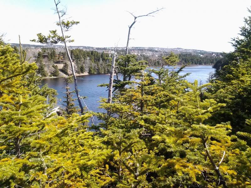
I'm pretty sure it's safe to say that no one has ever taken a picture from this particular spot. With the tiny bit of open space and another glimpse of the river I plunged once again into the bush with renewed determination.
Another 15 or 20 mins later I came out of the bush and into back corner of someones backyard which was a huge surprise to me. I followed their property line out onto the road which was called "Smith's Place"(North of the 5km marker on my Runkeeper map). Disappointed as I was for being unable to locate the other side of the trail, I was relieved that Smith had built this Place because I was really fed up of eating trees.
Hurdle #4 cleared
I stopped for a few minutes to empty the pine needles out of my jacket, shirt, pants and shoes. Don't ask me how, but both of my shoe laces were un-looped and knotted... I really should've taken a picture.
With the pine needles removed and shoes un-knotted I made the much easier 2km trek home.
Energetic from the phone call I got out of bed, had a healthy breakfast and took care of some minor stuff waiting for a call into work. Noon came and went without a call from work, so I figured it was safe bet that I wasn't going to be called in. Since I wasn't going to get any exercise from work I decided to go for a long walk, which turned into more of a walkabout, in the sense that I had know idea where I was going, or where I'd end up.
Here's a screenshot from my RunKeeper account:
Around the mid-point between the 3km and 4km marker the trail came right down to the rivers edge, which was way higher due to tons of rain and melted snow. I had to carefully step and jump from spot to spot to avoid getting wet. Hurdle #1 cleared
About 5 mins later the trail started to climb up higher and I came to a fork in the trail. I had the choice of following the main trail that looked like it headed east and possibly back out to a road, or turn left and continue north towards the ocean. My hope was (A) that the left trail would go all the way to the ocean, and (B) that there was a way to cross to the other side of the river, and (C) find a trail heading back in the opposite direction. That was a lot to hope for, so naturally I chose the latter.
The side trail wasn't as well maintained or traveled, but it was still fun. At the 4km marker the trail ended at Worsley Park which I didn't even know existed until I arrived. The park led down to the ocean/beach*, and extended across to the other side of the river... well most of the way, which meant that both (A) and (B) worked out.
*Beach - For those of you not familiar with Newfoundland the majority of our beaches are rocky, although we do have a few sandy ones.
To get across to the other side I ended up removing my shoes/socks, rolled up my pants up to mid-thigh and waded through the fast running bitterly cold water. Luckily it only came up a bit above my knee's. Hurdle #2 cleared
Once I was successfully on the other side I sat down on a rock facing the sun and waited a bit for my legs/feet to dry off before putting my socks/shoes on. While I was waiting I took the following 360 degree (shaky) video which starts looking from over my left shoulder.
I had to climb up that big hill that was mostly loose rock/dirt and I managed to eventually find a very narrow overgrown trail that headed in the right direction. Hurdle #3 cleared
This is the trail before it got to narrow to take a picture
The trail started off high above the water, but shortly took a turn down a slope towards the water... actually into the water. I now had 2 options: (A) walk +4kms back the way I came, or (B) Head through the bush and hope I could pick up the trail somewhere further north of my present point. Since it was still early in the day, and I had both the sun and river to guide me I once again chose the latter and plunged into the bush.
To say that the tree's were dense was an understatement. If you take all the empty space out of the above picture and replaced it with trees that would give you a pretty good idea. I couldn't see anything in front, behind or to either side. Half the time I couldn't even see my feet. Good thing I'm not closterphobic.
Fifteen minutes into the bush I started to second guess my decision. I could no longer see/hear the water and what felt like a 1km trek was probably only 50m of progress. I was about to turn around when I managed to see this:
I'm pretty sure it's safe to say that no one has ever taken a picture from this particular spot. With the tiny bit of open space and another glimpse of the river I plunged once again into the bush with renewed determination.
Another 15 or 20 mins later I came out of the bush and into back corner of someones backyard which was a huge surprise to me. I followed their property line out onto the road which was called "Smith's Place"(North of the 5km marker on my Runkeeper map). Disappointed as I was for being unable to locate the other side of the trail, I was relieved that Smith had built this Place because I was really fed up of eating trees.
Hurdle #4 cleared
I stopped for a few minutes to empty the pine needles out of my jacket, shirt, pants and shoes. Don't ask me how, but both of my shoe laces were un-looped and knotted... I really should've taken a picture.
With the pine needles removed and shoes un-knotted I made the much easier 2km trek home.
![]()


0 Comments:
Post a Comment
<< Home